GPS verification marks
 GPS verification marks are signs installed at selected boat ramps to be used by boaters to check the accuracy of onboard GPS navigation equipment. Signs that display verified GPS coordinates and are installed at boat ramps in coastal locations between Southport and Port Douglas. The signs have been installed in locations that are easy to access either on water or on land (for example, in rigging areas).
GPS verification mark locations
Signs are currently being installed across Queensland. GPS verification mark signs have been installed at the following locations:
Gold Coast
- Jacobs Well
- Harley Park, Labrador
- Proud Park, near Sundale bridge
- Muriel Henchmann Drive, beside the Volunteer Marine Rescue base at The Spit
Brisbane
- Scarborough, northern ramp
- Scarborough, near the Australian Volunteer Coast Guard
- Cabbage Tree Creek
- Manly, ramp beside Royal Queensland Yacht Squadron
- Manly, ramp beside Moreton Bay Trailer Boat Club
- Raby Bay, William Street
- Wellington Point
- Redland Bay
- Victoria Point, Colburn Avenue
Sunshine Coast
- Eudlo Creek, Fisherman's Road
- Golden Beach, powerboat club boat ramp
- La Balsa Park
- Maroochydore – Cod Hole, Bradman Avenue
- Mooloolaba Harbour, Parkyn Parade
- Thomas Street Noosaville
Urangan
- Snapper Creek, Tin Can Bay
- Carlo Point
- Burrum Heads
- Urangan Boat Harbour
- Gatakers Bay
- Big Tuan
- River Heads
Bundaberg
- Walker's Point, Woodgate
- Elliot Heads, River View
- Burnett Heads Boat Harbour
Gladstone
- Calliope River
- Gladstone Marina
- Bray Park ramp, Tannum Sands
Yeppoon
- Rosslyn Bay Boat Harbour
Mackay and Whitsundays
- Mackay Marina
- Pioneer River, River Street
- Hay Point Tug Harbour
- Victor Creek
- Eimeo Creek – Bucasia
- Eimeo Creek – Eimeo
- Sarina Inlet
- Pioneer Bay, near Volunteer Marine Rescue
- Shute Harbour
Townsville
- Barnicle Street upstream ramp
- Dungeness
- Bowen State Boat Harbour
- Nelly Bay Harbour (Magnetic Island)
Far north Queensland
- Mourilyan boat ramp
- Tingira Street boat ramp
- Yorkey's Knob
- Port Douglas boat ramp
- Clump Point boat ramp
- Flying Fish Point boat ramp
- Cooktown, Charlotte Street
- Thursday Island, Rose Hill
- Karumba Point, Palmer Street
- Weipa
How to use GPS verification marks
- From the list of GPS verification mark signs determine the most convenient location to where you would normally launch or operate your boat.
- On arrival at the selected location, position your boat next to the GPS verification sign.
- As part of your launch preparations, turn on your GPS system and compare the sign coordinates to those displayed on your screen. Keep in mind a GPS system does take a little time to initialise and stabilise before displaying accurate coordinates.
- Consider that a minor variation is expected due to the difference between mark location and the placement of your GPS unit on board.
- Coordinates are displayed in degrees, minutes and decimals of a minute.
- All coordinates are determined using WGS84 datum (compatible with GDA94).
How to compare sign coordinates to your GPS display

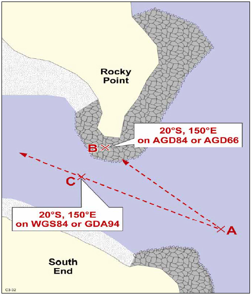
If your navigation equipment displays a significant variance to the position displayed, check that your system is using a base datum of either WGS84 or GDA94. This information should appear during system start up or on a system settings/information screen.
If your system is using the correct datum and still shows an inaccuracy of greater than 0.01 of a minute (see illustration above) you should contact the product manufacturer or retailer for advice.
Older datum such as AGD84 or AGD66 can display positions that may be inaccurate by 200m or more. Always update your GPS system with the latest software. GPS systems require regular updating to ensure all current objects and dangers are charted.
Tips on using a GPS unit
- Zoom in to the largest available accurate chart scale.
- Before heading out, switch the unit on and select the correct chart datum.
- Check electrical connections to prevent power failures.
- Make sure your GPS unit has the current software and up to date electronic charts.
- When going to a waypoint – check what is in between your boat’s initial location and the waypoint, which will be in a straight line.
Don’t rely on a GPS unit alone
While a GPS unit is a great aid to navigation, it must never replace the skipper's responsibility to keep a proper lookout. Over-reliance on a GPS unit can be dangerous, particularly at night, so always travel at a safe speed and maintain a lookout. If you are not sure where you are, double check your position using another method, for example a chart and compass.
These requirements are outlined in the International Regulations for the Prevention of Collisions at Sea (the collision regulations). Two important rules from the collision regulations about safe navigation are:
-
Rule 5—Lookout
Every vessel shall at all times keep a proper look out by sight and sound, as well as by all available means appropriate to the circumstances in order to make a full assessment of the situation and of the risk of collision. -
Rule 6—Safe speed
Every vessel must proceed at a safe speed so that action can be taken to avoid collision and to be able to stop within a distance suitable to the prevailing conditions, for example visibility, traffic conditions and weather conditions.
Using a GPS unit does not exempt a skipper from complying with the rules of the collision regulations.