Mooloolaba boat harbour dredging
Mooloolaba Boat Harbour entrance review
On 17 September 2025, the Honourable Brent Mickelberg MP, Minister for Transport and Main Roads, announced an independent peer review into the recurring shoaling events at the Mooloolaba Boat Harbour entrance.
The Queensland Government appointed coastal engineering specialists RPS, supported by International Coastal Management, to examine:
- what causes shoaling
- how coastal processes are affecting the entrance
- the benefits of current dredging
- the short and long-term options available.
Due to unpredictable weather and swell conditions, dredging activities to clear sand shoals from the navigational entrance channel are not always immediately possible and a long-term solution is required to minimise the impact of these shoaling events.
These events have heightened concerns about the unpredictability of these shoaling events and what (if anything) can be done to better address them.
RPS investigated the ongoing shoaling events, and the impacts these have had on coastal process and the Mooloolaba Boat Harbour entrance.
The report provides technical advice only and does not commit the Government to any specific policy, funding or delivery decisions. The Queensland Government will update the community on next steps once decisions are made on the options outlined in the report, including any funding allocated through the Budget process.
Final report
The final report was received for consideration in late 2025 and the Queensland Government has now released the findings of the independent review.
Read the independent review final report.
Scope
The review included, but was not limited to:
- developing short-term recommendations to stabilise the situation for consideration by government
- undertaking a desktop review of previous reports and studies relating to the cause and impacts of shoaling events
- confirming causes for the shoaling events
- identifying impacts of the shoaling events
- assessing the effectiveness and impact of options to prevent and/or mitigate shoaling events as they relate to a wide range of stakeholders
- developing longer-term recommendations to reduce risk of shoaling events
- undertaking consultation with the stakeholder reference group regarding causes, impacts and short-term and longer-term recommendations
- consideration of the impact arising from any proposed intervention on the community, tourism operators, maritime and recreational users
- any other relevant matters the independent reviewer considers appropriate to the review.
Mooloolaba boat harbour dredging
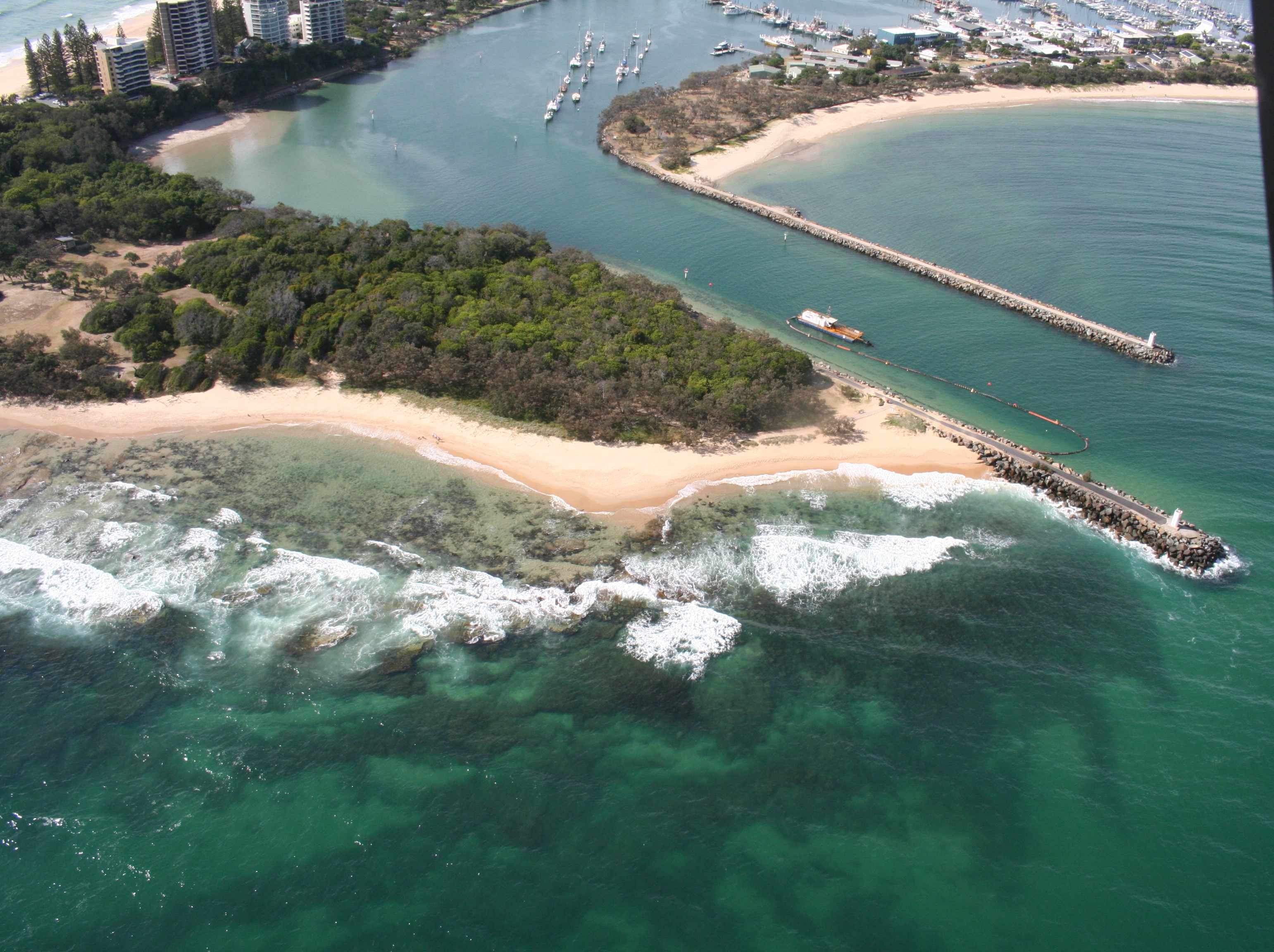
The Mooloolaba harbour and entrance training walls were built in the late 1960's. Since that time, sand shoaling events have occurred periodically in the entrance channel, causing marine safety and accessibility issues.
Maintaining a safe navigable entrance to the Mooloolaba Boat Harbour at all times is crucial for all boaties. We aim to maintain the boat harbour entrance clear to a design depth of at least -2.5m Lowest Astronomical Tide (LAT) at all times.
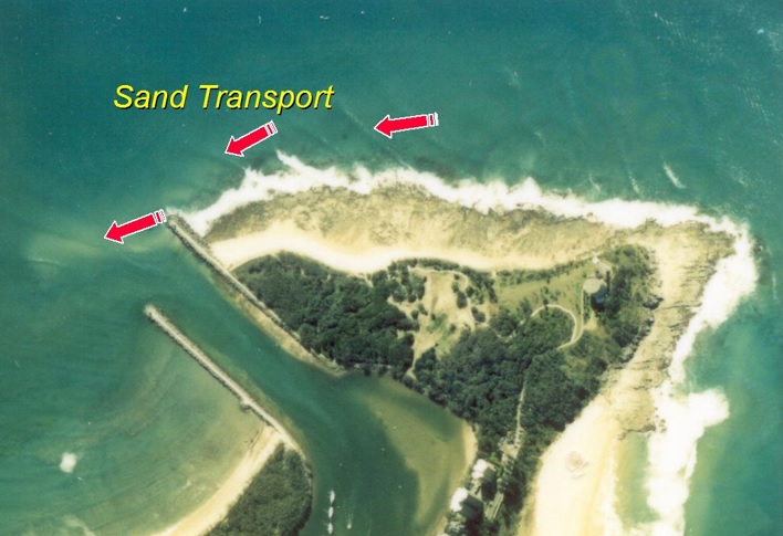
Channel shoaling
During a shoaling event, sand accretes to form a shoal (like a sand bar). This shoal reduces the water depth, making navigation more hazardous. During these shoaling events, sand runs along the headland and feeds the entrance shoal.
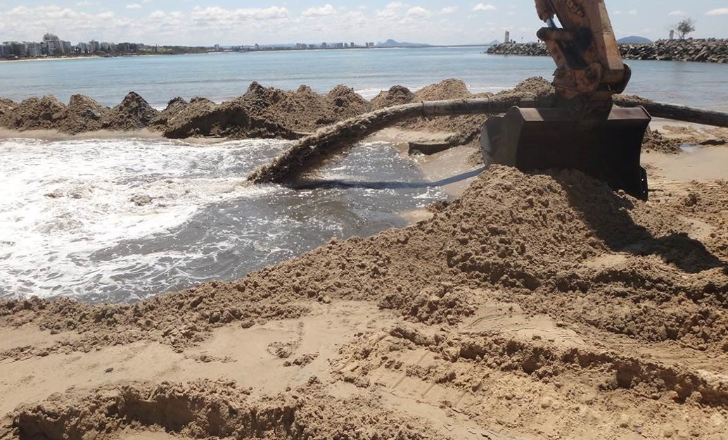
Dredging activities are carried out to improve the safety of the boat harbour entrance. These activities involve removing the sand shoal by pumping the sand onto Mooloolaba Beach. The dredge stays in position and continues to remove sand until safe depths are reached.
In the past, shoaling events were infrequent, occurring every few years, with intervals of 3-5 years or longer. In the last 15 years shoaling events have become more frequent and major shoaling events in 2011-12 and 2022 have required continuous dredging for long periods and had a significant impact on navigational access.
An additional challenge is the wave conditions that tend to drive sand into the entrance. These greatly impact on vessel navigation as well as impacting the ability to safely undertake dredging activities to remove the hazard.
Current dredging strategy
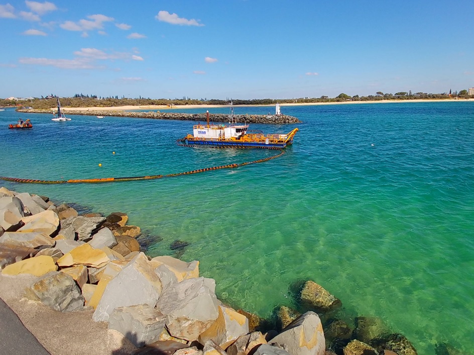
Local Sunshine Coast contractor, Hall Contracting, are currently contracted to dredge the channel entrance.
This arrangement allows a dredge to be available on short notice, with cost effective establishment and standby rates. A small cutter suction dredge is used, as this plant is manoeuvrable and small enough for boaties to pass safely whilst in use and maximises time on task through a shallow vessel draught.
Some stakeholders have suggested that a much larger dredge would be better, however this is not the case. The current cutter suction dredge being used has a smaller draught and is less likely to hit the bottom of the channel and damage either the dredge or its cutters/suction points. The smaller dredge also dredges from the calmer waters outwards rather than a larger dredge operating from seaward into the channel where it is constantly exposed to ocean swells. This approach helps ensure a safer and more stable operation. The smaller dredge also has the additional benefit of being able to place the sand anywhere via pipeline which means sand can be placed directly on the Mooloolaba beach to aid storm recovery.
A permanent pipeline was installed in 2013 along the eastern breakwater wall and runs across the channel anchored on the riverbed. The dredged sand is pumped onto Mooloolaba Beach by the pipeline that runs around the bay under the beach with specific outlet points. This makes dredging more efficient with less impact on boaties accessing the harbour and allows flexibility in meeting Sunshine Coast Regional Council’s desired beach nourishment objectives.
Current dredging work
Western channel trial
The dredging contractor mobilised to the site to clear the current shoal in mid-March 2025 following TC Alfred. This represented the third maintenance campaign of a trial dredging program that commenced in November 2022.This trial dredging program involves dredging the entrance channel but also dredging sand banks to the west of the Mooloolaba entrance channel, as well as dredging to a deeper depth than normal with the intended objective of decreasing the impact on navigation of subsequent shoaling events. This approach is different to previous programs which involved just dredging the entrance channel.
This trial program was implemented based on feedback from the local stakeholder reference group. We formed this group to provide local advice and to help investigate long-term solutions for the Mooloolaba Boat Harbour entrance shoaling issue.
To date following shoaling events in 2024 and 2025 indicate it has been reasonably effective at maintaining an alternate access (west) during shoaling events, particularly in periods when dredging in the entrance channel was not possible due to poor weather.
In line with feedback from the SRG, we are continuing the trial with further development of elements to improve its effectiveness.
Hydrographic surveys
Hydrographic surveys continue to be carried out regularly to monitor depths in the entrance channel, when weather conditions allow.
Entrance monitoring cameras
In July 2021, we installed cameras to monitor the wave conditions and dredging activity at the channel entrance. The cameras are fixed to the 2 towers at the end of each Mooloolaba breakwater, looking down into the channel. A photo is taken every 15 minutes.
Shoal Monitoring Pilot Project
Given the early positive outcomes from the western channel trial, we've instigated a pilot project to remotely monitor the shoal location during shoaling events. This project includes the trial of drone image captures and Satellite Derived Bathymetry with the objective of capturing frequent spatial information on the shoal location. This will allow effective and timely feedback to mariners on the best available passage of water to navigate through the entrance channel.
The pilot project will also assess the ability for drone images and Satellite Derived Bathymetry to provide suitable entrance depth information when rough weather delays hydrographic surveys.
Mooloolaba Harbour entrance long-term solution
A long-term solution to maintain safe navigable access at the Mooloolaba Harbour entrance is currently being investigated. For more information about our investigations, visit Mooloolaba Boat Harbour entrance, long-term solution.
Mooloolah River entrance bar
Boaties are reminded that coastal bars are constantly changing. Plan your crossing of the Mooloolah River entrance bar and navigate with caution.
The Mooloolah River entrance is a designated coastal bar. For more information about staying safe and the lifejacket rules for crossing a coastal bar, visit Coastal bar crossings.
Stay up-to-date with the latest Notice to Mariners advice to see if your crossing will be impacted.
Before heading out, you can also click here to view the live cameras at the entrance to check current conditions and assist with planning your trip safely.